for the Old Testament prior to 1200 B.C.E.
#. (2.0) Identify the following ancient people groups with the correct description:
| ___ (1) Sumerians | a) A Semite people from whom the later Israelite originated. |
| ___ (2) Akkadians | b) Called the Horites in the Hebrew Bible; the clay tablets at Nuzi has helped clear up many obscure passages in the Hebrew Bible. |
| ___ (3) Amorites | c) The OT Sons of Heth who invaded Palestine and Egypt from their homeland of Asia Minor around 1400 B.C.E. |
| ___ (4) Hurrians | d) Often mistakenly identified with the Hebrews because of the similarity of names. |
| ___ (5) Arameans | e) developed two strong states in Mesopotamia around 1800 B.C.E.: Mari and Babylonian. |
| ___ (6) Habiru | f) Invented the earliest known form of writing (cuneiform) and introduced counting by sixties (the method we use to count minutes and hours). |
| ___ (7) Hittites | g) semi nomadic tribesmen from Arabia often identified with the Amorites. |
___ #. (2.1)
The Fertile Crescent is
a) a scattering of oases enabling desert travel in the Middle East.___ #. (2.1) An alternative term for 'Fertile Cresent' that is found in the NOSB3 essay is:
b) the V-shape image created by the Gulf of Suez and the Gulf of Aqabah around the lower half of the Wilderness of Sinai.
c) A rough crescent-shaped pattern of watered areas beginning on the east at the Persian Gulf, running through Palestine, and ending at Egypt.
a) Mesopotamia b) Levant c) Palestine
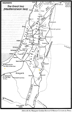
#. (2.1)
From the online map
explain why the highlighted area takes on an upside down U shape:
___ #. (2.1) The importance of the Fertile Crescent is that the watered areas enabled the existence of civilizations and thus travel between the eastern Mediterranean Sea and the Persian Gulf.
| a) True | b) False |
#. (2.2)
Identify the correct time frame for the following ethnic groups in ancient
Mesopotamia.
a) 3000 to 2000 BCE
b) 2000 to 1500 BCE
c) 1500 to 1000 BCE
| ____ (1) Arameans | ____ (4) Sumerians |
| ____ (2) Akkadians | ____ (5) Hurrians |
| ____ (3) Amorites | ____ (6) Habiru |
| a) True | b) False |
____ #. (2.2.1.1)
The Sumerians were located in
| a) Mesopotamia | b) Asia Minor | c) Egypt |
____ #. (2.2.1.2)
The Akkadians were located in
| a) Mesopotamia | b) Asia Minor | c) Egypt |
____ #. (2.2.2.1)
The Amorites were located in
| a) Mesopotamia | b) Asia Minor | c) Egypt |
____ #. (2.2.2.2)
The Hurrians were located in
| a) Mesopotamia | b) Asia Minor | c) Egypt |
____ #. (2.2.3.1)
The Habiru were located in
| a) Mesopotamia | b) Asia Minor | c) Egypt |
____ #. (2.3.1)
The Hittites were located in
| a) Mesopotamia | b) Asia Minor | c) Egypt |
___ #. (2.4)
Although the Nile River now plays an important role in modern Egypt, it
had very little significance in the ancient world.
| a) True | b) False |
___ #. (2.4)
Egypts semi-isolation from the rest of the Fertile Crescent allowed its
civilization to develop with a minimum of interruption from outside forces.
| a) True | b) False |
____ #. (2.4.1) Which period was the
time of the building of the great pyramids in Egypt?
| a) 3000 to 2000 BCE | b) 2000 to 1000 BCE |
___ #. (2.4.2)
The Hyksos were
a) a shepherd nomadic people who lived in the Nile delta area of ancient Egypt.
b) a conquering warrior people from the outside who ruled Egypt from 1720 to 1570 B.C.E.
c) a Semitic group of people from Arabia who invaded territories in the Fertile Crescent.
____ #. (2.4.2)
Which period was the general time of the Hebrew Exodus from Egypt?
| a) 3000 to 2000 BCE | b) 2000 to 1000 BCE |
___ #. (2.5.1)
The importance of the archaeological discoveries at Elba in northern Syria
is that data gathered there
a) confirmed the Egyptian invasion of Syria by pharaoh Ahmose I in 1570 B.C.E.___ #. (2.5.1) Although at first appearing insignificant, the archaeological discoveries at Elba now are proving to be very significant for Old Testament studies.
b) identified the origin of the Hyksos, the foreign invaders of Egypt in 1720 B.C.E.
c) established that a major civilization existed in Syria prior to 2000 B.C.E.
| a) True | b) False |
___ #. (2.5.2)
The Ras Shamra texts were discovered at the Canaanite city of Ugarit.
| a) True | b) False |
___ #. (2.5.2)
The Ras Shamra texts have been invaluable for helping to understand Hebrew
Bible texts and history.
| a) True | b) False |
___ #. (2.6.1)
The middle eastern geographical region that holds the greatest fascination
to the Western world is
| a) Asia Minor | b) Egypt | c) Palestine |
#. (2.6.2) Identify the following references with the correct division of Palestine.
a) The coastal plain on the Mediterranean coast
b) The central hill country
c) the Jordan Rift
d) the Transjordan Plateau___ (1) the southern part is known as the Plain of Philistia.
___ (2) the location of Galilee
___ (3) the location in modern times of the Golan Heights
___ (4) the home of the Philistines
___ (5) the location of the city of Megiddo
___ (6) the location of the city of Gaza
___ (7) the location for the Sea of Galilee
___ (8) the channel for the Jordan River
___ (9) the location of the ancient country of Moab
___ (10) the location of Judaea
___ #. (2.6.2) The Shephelah is located
in
a) the northern region of Palestine near the Sea of Galilee.
b) between the coastal plain and the central hill country.
c) the southern region of Palestine near the Negeb.
___ #. (2.6.2)
How did the Shephelah function in biblical times to protect the area of
Judah?
a) the high cliff at the beginning of it made things difficult for invading armies.
b) the high, steep mountains bordering the Jordan River protected Judah from armies coming from the east.
c) the north-south valleys between the Shephelah and Judah made invasion of Judah from the Mediterranean coastal plains very difficult.
___ #. (2.6.2)
The Jordan River in ancient times was of little economic importance because
a) Unlike the other rivers, its valley was formed by an earthquake, not carved out by the river. Thus the soil in the surrounding valley is not very fertile.
b) The Jordan River floods at the wrong time of the year, usually destroying crops grown in the surrounding valley.
c) Both of the above.
d) Neither of the above.
___ #. (2.6.3)
Which of the following major north-south routes in Palestine was located
east of the Jordan River?
| a) the Via Maris | b) The Kings Highway |
___ #. (2.6.3)
Which of the following major north-south routes in Palestine was located
mostly along the Mediterranean coastal plains?
| a) the Via Maris | b) The Kings Highway |
#. (2.6.3)
Explain why both the Via Maris and the Kings Highway were important in
ancient times?
#. (2.6.3)
On the map below indicate approximately where Moses and the children of
Israel were located when Moses requested permission to pass through Edom
according to Num. 20:14-21:
14 Moses sent messengers from Kadesh to the king of Edom,
"Thus says your brother Israel: You know all the adversity that has befallen
us: 15 how our ancestors went down to Egypt, and we lived in Egypt a long
time; and the Egyptians oppressed us and our ancestors; 16 and when we
cried to the Lord, he heard our voice, and sent an angel and brought us
out of Egypt; and here we are in Kadesh, a town on the edge of your territory.
17 Now let us pass through your land. We will not pass through field or
vineyard, or drink water from any well; we will go along the King's Highway,
not turning aside to the right hand or to the left until we have passed
through your territory." 18 But Edom said to him, "You shall not pass through,
or we will come out with the sword against you." 19 The Israelites said
to him, "We will stay on the highway; and if we drink of your water, we
and our livestock, then we will pay for it. It is only a small matter;
just let us pass through on foot." 20 But he said, "You shall not pass
through." And Edom came out against them with a large force, heavily armed.
21 Thus Edom refused to give Israel passage through their territory; so
Israel turned away from them.
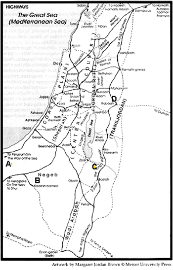
a) A
b) B
c) C
d) D